
The commune in figures
Mamer
Population: 8,272*
Area: 17.2km²
Forest area: 5km²
Farmland: 8.6km²
Elevation: 297 m (Church)
*(au 31 décembre 2025)
Capellen
Population: 2,537*
Area: 3.2 km2
Forest area: 0.2 km2
Farm area: 1.8 km2
Altitude: 323 m (Church)
*(au 31 décembre 2025)
Holzem
Population: 772*
Area: 7.4km²
Forest area: 0.7km²
Farmland: 5.9km²
Elevation: 300 m (C.R. 101/C.R. 103)
*(au 31 décembre 2025)


The “Mamer Schlass”, seat of the municipal administration
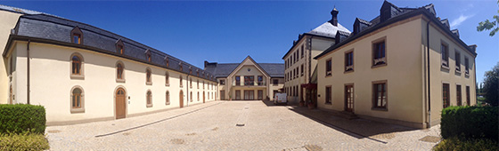
Since March 1, 2002, the offices of the Mamer municipal administration have been located in the fully restored premises of Mamer Castle, known as the “Mamer Schlass”.
A historical and cultural complex
The “Mamer Schlass” is a complex consisting of four buildings surrounded by a charming park. Behind the main building, asculpture pays tribute to two iconic sports figures from Mamer: Nicolas Frantz, two-time winner of the Tour de France, and Josy Barthel, the 1952 Olympic champion in the 1,500-meter race in Helsinki.
A renovated heritage
The origins of the “Mamer Schlass” date back to 960, when Countess Liutgardis donated the hamlet of Mamer to the Abbey of Saint-Maximin in Trier. It is likely that a building already stood on the site at that time. In 1796, the French Republic declared all properties belonging to religious communities to be state property, including the ruined castle in Mamer.
In 1798, the estate was auctioned off and divided into four lots; the castle was purchased by Thierry de Bastogne. In 1830, Frédéric François, then district commissioner, rebuilt the castle into its current form and enclosed his entire estate with a 2-meter wall. He also created a 25-are pond at “Le Brill.”
The château then passed to Georges Ulveling, member of parliament for the canton of Capellen in 1919, before being acquired in 1934 by Jacques Fischer and Julie Kremer for farming.
In 1995, the municipality of Mamer bought the castle and decided unanimously at its meeting on June 4, 1997 to restore the “Mamer Schlass”.
Restoration work began in September 1999 and was completed at the end of February 2002, restoring the château to its former splendor and transforming it into a modern administrative center.
We invite you to come and explore this iconic site, a symbol of our town’s heritage and history.
Twinning with Dangé-Saint-Romain (France)
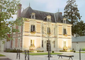
Since 1976, the town of Dangé-St-Romain, located in the Vienne department of France, has been twinned with the town of Mamer. The twinning charter was signed in Mamer on May 23, 1976, and in Dangé-St-Romain on July 14, 1976.
Discovering Dangé-St-Romain
Dangé-St-Romain is a charming French village with a population of 3,300, nestled on the border between Touraine and Poitou. Thanks to its location, equidistant from Tours to the north and Poitiers to the south, it seamlessly connects the Loire Valley castles—a symbol of a prestigious historical past—with Futuroscope, a symbol of a cutting-edge technological future.
The village stretches along the Vienne River and the Paris-Bordeaux corridor, offering many amenities for a pleasant stay or a brief stopover. Dangé-St-Romain features a shaded two-star campground along the river, ideal for fishing enthusiasts, as well as a swimming pool, five tennis courts, and hiking trails.
The village also has all the necessary shops and services, with a lively market on Tuesday and Saturday mornings, as well as several restaurants to delight gourmets.
Saveurs et Accueil de Dangé-St-Romain
Regional specialties in Dangé-St-Romain include farci poitevin and broyé du Poitou, tasty dishes that pair perfectly with Haut-Poitou wines and locally produced goat’s or cow’s milk cheeses.
The people of Dangé-St-Romain, known as the Dangéens, are renowned for their affability and warm welcome. They will be delighted to welcome you and share with you the riches of their village and their region.
For further information:
Office de Tourisme
Place de la Promenade
F-86220 Dangé-Saint-Romain
Tel: 0033 49864057
or
Mairie de Dangé-Saint-Romain
Tel: 0033 498640 01
Map of the Municipality of Mamer
